home artwork/initiatives statement résumé individual artwork news associates collaborators publications views, vista & reverie contact
 
  - ATLAS
  - Pylons
  - Masts
                 
 
Produces artworks, exhibitions, environmental initiatives, papers for publication. (see PLACE résumé)

Facilitates debate and exchange around art, society, infrastructure, architecture and the environment.

 
ARTWORK / INITIATIVES - ATLAS
The ATLAS project began after visits to the developments in the Cardiff Bay area in the early 1990s, and observations and photography of the changing sedimentary mud formations in the disused Mount Stuart Graving Docks at the Inner Harbour, Cardiff Bay.
  photographs: Richard Page
The west dock photographed with the tide out.  The west dock photographed with the tide in.
Part of the ATLAS project consists of photography of the sedimentary mud formations in the Mount Stuart Graving Docks before they were flooded by the operation of the new Cardiff Bay Barrage in 1999.  The images below are from an archive of several hundred slides some of which make up a two projector slide projection work.
 
photograph: Jonathan Adamson photograph: Andrew Darke
 
Plan of the Cardiff Bay Aeration System
copyright Cardiff Harbour Authority
 
Dr. R. J. W. Cowell says of PLACE proposals for the Mount Stuart Graving Docks and Cardiff Bay
(see ATLAS Synopsis)

“I found your ideas fascinating and share your view that there is considerable educational potential and aesthetic merit in retaining the mud and inundation cycles [in the Graving Docks] . . .

There is also an intriguing irony in the deliberate maintenance of formerly ‘natural forces’, particularly with your second option of simulating the tidal cycles by mechanical means.  Indeed, both of your proposed technical options share some unsettling aspects.  In addition to reflecting on the forms in the mud, the observer might contemplate how this essentially residual estuarine spectacle is maintained, and muse on relations between the ‘natural’ and ‘human-made’.  One might conceive of the mud display as a mournful echo of the once large mudflats of Cardiff Bay.  ‘Wild’ ecosystems, once fed by the tides, are placed on a ‘drip’ or ventilator, at the mercy of human ‘doctors’! 

While disturbing, I believe this to be a valuable consideration, prompting the visitor to contemplate on the processes- organic, economic and technological- that shape landscapes, and affect their long-term sustainability.”

 
Photographs of the Cardiff Bay Aeration System in operation 2008
photographs: Andrew Darke
 
LOST HORIZONS - NO BARRAGE
  photomontage: Andrew Darke
On the reverse: horizon contemplation prospect perspective vista open divulge reveal discover unfold acknowledge allow unveil extend stretch reach spread distant far yonder remote clear bound On the reverse: barrage hinder impede prevent bar inhibit scotch  squash cramp restrain check thwart frustrate balk stymie spoil mar curb shacklefetter stonewall 
 
PLACE artwork - a pair of postcards (a precursor to the main ATLAS project working with similar material, before the barrage was a fait accompli)
The postcards were published by PLACE in 1994 with funds from the Severn Estuary Conservation Group before the Cardiff Bay Barrage was built. They were sent to MPs.  Rhodri Morgan, MP for Cardiff West, wrote to PLACE saying the cards were “absolutely brilliant.” He described the shutting out of the sea (by the then proposed barrage)  from the envisaged “superlative maritime city” (Cardiff Bay Development Corporation) as a “wondrous irony” and said he deeply regretted the way the barrage would  prevent the reintroduction of salmon and sea trout into the Taff and Ely rivers.

At the same time PLACE sited a billboard poster in Cardiff using the “Lost Horizons” image as above.

 
  see ATLAS Synopsis for a fuller account
 
______________________________________________________________________________________________________________________
^ top
ENVIRONMENTAL INITIATIVES (Ongoing Projects)
  • to reduce the intrusion of electricity transmission lines in rural landscapes - Pylons
  • to reduce the intrusion of mobile telecoms infrastructure in rural landscapes – Masts

Less intrusive solutions already exist. Why have high impact infrastructures been built without using these solutions?

Often companies allege technical, financial and legal difficulties stop them using these better solutions. With will and innovation such problems can be solved. The principal problem is the relatively low priority given by both government and commerce to the protection and enhancement of the environment.

Part of PLACE’s work is to research and document less intrusive environmental practice that could be used more widely. Publicity is needed to alert people to less ntrusive possibilities. Examples can be used as leverage on government and industry.

 
NATIONAL GRID OVERHEAD TRANSMISSION LINES - PYLONS
PLACE has been in correspondence with National Grid (NG) and the Peak District National Park Authority (PDNPA) for over six years, about the Thorpe Marsh to Stalybridge 400kV overhead transmission line, approximately nine miles of which runs through the Peak District National Park (PDNP). The line is a major intrusion in the NP and dominates Longdendale to the west and the Upper Don Valley to the east of the pennines damaging the quality of a fine landscape in this part of the NP.

The statutory duties laid upon NG and PDNPA policies require them to reduce the intrusiveness of the line during refurbishments / upgrades. A major refurbishment began in 2007 and PLACE is now an offical consultee for NG on this project. During the 13/7/07 planning committee meeting of the PDNPA, NG was asked to improve its public consultation efforts; a question remains as to how well the statutory duties and policies are being followed.

PLACE has initiated a project advocating increased ‘undergrounding’ of the line during the works and is collaborating fully with the Campaign for the Protection of Rural England (CPRE) and the Peak District National Park Authority (PDNPA). Three cards have been produced (Pages 1-3 and below) and a leaflet asking for letters to be written to PDNPA was distributed with CPRE’s July 2007 issue of “Peakland Guardian.” (16 were received)

A pair of folded A4 cards show landscapes as they would be if the present overhead transmission lines (OTLs) were undergrounded / surface troughed. The cards also compare different transmission systems.

 
photograph: Andrew Darke
 

Produced by PLACE in collaboration with Friends of the Peak District/CPRE South Yorkshire
Friends of the Peak District/CPRE South Yorkshire
22a Endcliffe Crescent, Sheffield  S10 3EF
tel. +44 (0)114 266 5822  
e.mail: info@cprepeakandsyorks.org.uk

contact:
PLACE 
Jonathan Adamson
Tower House, Cemetery Road, Edgerton, Huddersfield HD1 5NF 
tel. +44 (0)1484 536103
Andrew Darke
Field House, Yorkley Wood, Nr. Lydney, Gloucestershire GL15 4TU 
tel. +44 (0)1594 562646
e.mail: place@phonecoop.coop  
see: www.p-l-a-c-e.org   

Details of the cards are shown below

pp.1, pp.2 of the left-hand card

(Note for on-screen readability, information in the margins of both cards has been removed and placed above.)

A new vision for Longdendale in the Peak District National Park and the Upper Don Valley
Longdendale would be like this if the 400kV overhead transmission line were undergrounded/surface troughed The Upper Don Valley would be like this if the 400kV overhead transmission line were undergrounded/surface troughed
   
pp.3, pp.4 of the left-hand card
   
pp2,3 of the right-hand card
   
pp4,1 right-hand card (back page, front page)
 
PLACE / CPRE leaflet which was circulated with the July ’07 issue of “Peakland Guardian”  replaced the Pamela Day drawing with the image and text below.
pp1 and pp4 (front page, back page)
   
PLACE/CPRE leaflet July 07 pp2, pp3 (inside pages)
   
PLACE/CPRE leaflet July 07 pp2, pp3 (inside pages)
   
Best Practice
  photograph: Andrew Darke
NG 400kV cables run under these moors in a disused railway tunnel between Longdendale and the Upper Don Valley. Grid Ref.  SE135 013
   
PLACE artwork – a four panel card
  photomontage: Andrew Darke
 
PLACE artwork – panels 1 & 2 of “Text and Image Collage” PLACE 2007
   
PLACE artwork – panels 3 & 4 of “Text and Image Collage” PLACE 2007
 
On the reverse of panel 4

Images: the pair of photographs titled “Industrialization”
(from the project “The History Lesson” 1982), in
“REMODELLING PHOTO HISTORY 1981 TO 1982:
A Collaboration Between Two Photographers
Terry Dennett and Jo Spence”

Published in:
“PUTTING MYSELF IN THE PICTURE” JO SPENCE
Camden Press Ltd. London 1986

Reproduced with the permission of Terry Dennett,
Curator of the Jo Spence Memorial Archive.

This card is published as part of PLACE advocacy for
 increased ‘undergrounding’ of the National Grid,
particularly in and around National Parks and
Areas of Outstanding Natural Beauty.


  Enclosures.. 2008.. collage by Andrew Darke
 
  To download a PDF version of this document - click here
If you require the PDF Adobe Reader - click here
______________________________________________________________________________________________________________________
^ top
MOBILE PHONE BASE STATIONS - MASTS

PLACE has worked to reduce the impact of mobile phone infrastructure over the last 11 years. A two year collaboration with the Forestry Commission (FC) to reduce the impacts of mobile phone base stations on the FC estate produced little effect owing mainly to a lack of co-operation from industry. All the mobile phone companies were both formally and informally invited to collaborate in a project with the FC and PLACE. Their response, via the industry association the Mobile Operators Association, was to re-iterate their view that technical constraints do not allow (for instance) the live tree solution (see below) to be used except in very few circumstances.  PLACE does not agree with this view, it is a smoke screen to avoid extra expense.
The FC has over 100 base stations on its estate and it has made clear that it wants a positive, innovative and collaborative project with the companies which will have benefits for all the community and the environment.

The current copy of the non-statutory Code of Best Practice on Mobile Phone Network Development published by the Office of the Deputy Prime Minister 2002, under paragraph 149: Design Innovation by Operators, states:

“If the impact of telecommunications development is to be minimised then it is essential that the telecommunications industry continues to develop innovative mast designs. The use of outside designers by operators will enable then to take on board fresh ideas. Operators are encouraged on a site by site basis to collaborate with each other in seeking new design initiatives. It would also be beneficial for operators to include the local authority and local community in the design process on a site by site basis.”

The Code also publishes an image of a live tree mounted antennae (see below) but there is no encouragement to use this system, indeed there is no reference to it in the text.

The use of the word ‘if’ at the beginning of paragraph 149, in tandem with the non-statutory status of the Code ensures that it is as toothless as it is possible to be in terms of controlling the industry. Repeated requests for base station developments to require a full planning application, the most recent being the All Party Parliamentary Inquiry into Planning Law as it Affects Mobile Phone Masts 2004, at which PLACE gave written and oral evidence, have been ignored by the government. In 2002 the government sold licences to the mobile phone industry for £22.5bn.

For examples of the approach taken by mobile phone companies to reduce the impact of their systems on communities and the environment see page 7 and Views, Vistas and Reverie pages 30-34; 101-2.

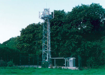
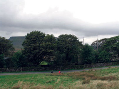
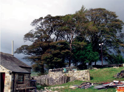
Below are examples of mobile phone base stations. To the right is the considerably less intrusive live tree base station with antennae attached directly to the trees (see white arrows). Once the shrubs have grown around the equipment cabin, this base station will be virtually invisible at 50m. Landowners and planners can require that this solution is used. Experience shows that the mobile operators are likely to raise a smoke screen of technical issues and cost to avoid using this method, although if their infrastructure were less intrusive they would clearly suffer much less aggravation from the public! There is one live tree base station in the UK that we know of and; there are ten or more in Norway where the technique was pioneered. It is strongly suspected that inertia and the low priority given to environmental matters by the companies are the only reasons the system has not been widely adopted. If it were, visual intrusions in rural and semi-rural areas could be vastly reduced.

 
 BAD PRACTICE BETTER PRACTICE
  photographs: Andrew Darke
A typical site by Orange. Grid Ref. SO584 020 Vodafone site No.4788 at Crieff, Scotland.  Grid Ref. NN864 224
Further examples of better practice
(which could still be improved!) see also “Views, Vistas and Reverie” / best practice
  photographs: Andrew Darke
Antennae mounted on wooden poles in the midst of a copse – photographed from the point of greatest visibility; barely visible from most view points; small  stone equipment cabin within copse.  O2 installation at Grid Ref. SD849 720 Modest cylindrical antennae mounted on the gable end of the barn; two small white dish antennae on a wooden pole within the tree canopy. Dishes would be improved if olive green. Installation barely visible from most viewpoints. Orange installation at Grid Ref.  SD903 615
 
See below for more distant landscape photographs of these installations
  photographs: Andrew Darke
Wood poles with antennae mounted on top concealed within the copse. Red arrow indicates cylindrical antennae on the barn, dishes on the pole concealed behind and within the copse to the left.


old god - new god.. 2008.. photograph looking towards Hghgate from Hampstead Heath by Andrew Darke
 
  To download a PDF version of this document - click here
If you require the PDF Adobe Reader - click here


home artwork/initiatives statement résumé individual artwork news associates collaborators publications views, vista & reverie contact
Content Copyright © 2007-09 p-l-a-c-e.org All Rights Reserved